

Was California Once an Island?
California curiosities and old maps

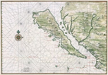
It was a long held belief that California was a large island separated by a gulf that stretched the entire west coast of North America. A cartographic error, or so they say. There are over 1000 maps depicting Isla de California, dating from the 16th century and the idea was propagated even into the 18th century.
Las Sergas de Esplandián (The Adventures of Esplandián) is a novel written by Garci Rodríguez de Montalvo. It’s a romance novel describing an island paradise inhabited by black women who lived like Amazons, “on the right hand of the Indies there is an island called California very close to the side of the Terrestrial Paradise.” So, it’s said that when the explorer Cortez sailed partially up the Gulf, he named the land after the novel’s fictional island, because of his limited knowledge of the area.
Although the story behind the naming of California sounds plausible, it was only first proposed in 1864. That’s 354 years after the earliest existing 1510 reprint date of the obscure novel, about a legend that has been told as early as the 14th century.
The Wikipedia version of how California got its name is interesting, but I’d like to imagine, what if California really was at one time an island?
San Andreas, a 2015 movie, depicts the fault line finally giving way and California sinking into the ocean. But what if that is not a future event, but actually a historical event? Mainstream geologists say that these kinds of changes take millions of years, but I still wonder exactly how much geological change can happen in a shorter span of time. I wonder exactly how accurate these old maps are, and if the novel about California as an island isn’t so fictional after all.
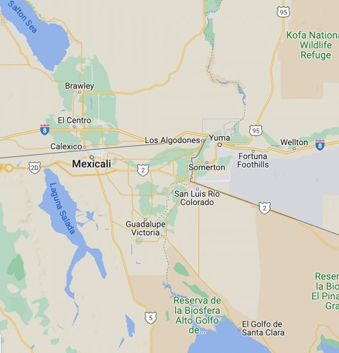
This map shows Yuma California, I found Algodones which was at one time spelled Alchedomas, you can see it at the top of this image below.

These old maps are fairly detailed, even depicting all the cities along the coastline, so how could the cartographers get California as an island so wrong? Cocomaricopas, is also on the map, which is now Maricopa County in Arizona.
The rare old map below also depicts the Colorado river emptying into the gulf, and it appears that the gulf is extending a bit farther north than it does today.

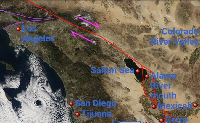
I wonder about some of the changes between 1604 and 1767 or even earlier. Are these changes just cartographer errors, or did the gulf actually extend farther north?

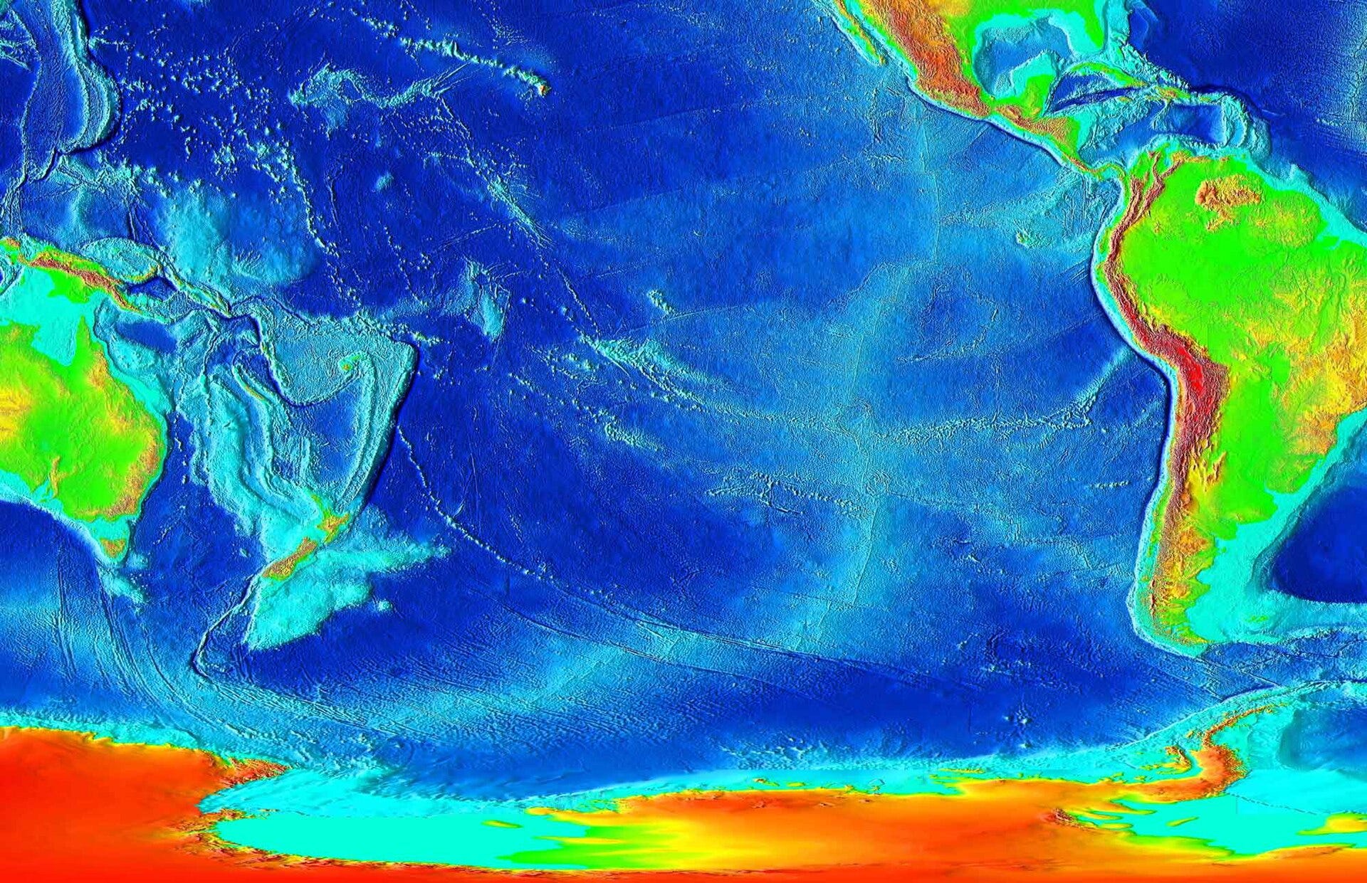
On the satellite image of the map, we can see more clearly that the gulf could have extended further north in those Mexicali valley areas. Current satellite images also show the seafloor which even looks like it may have at one time extended wider around Los Angeles, San Diego and Baja California.

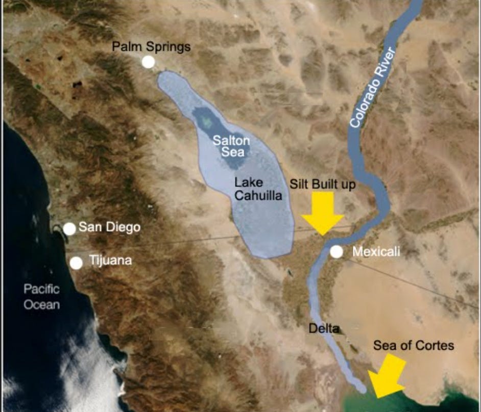
There’s also the curious issue of the Salton Sea. The Salton sea is shallow, landlocked, and situated right on the San Andreas Fault. The Colorado river once flowed into the surrounding Imperial Valley depositing soil, raising the terrain and shifting the river delta. 4,000,000 tons of dissolved salts enter the Salton Sea every year. That is about 13,500 train car loads!
Where does all that salt come from? I was thinking that maybe at one time the ocean actually flowed through there, however geologists say that the salt comes from agricultural drainage and the Colorado River. Really? Hmmm.
I imagine that possibly water once flowed freely through the Gulf, following the San Andreas fault line (marked in red), through the Gorgonino Pass (marked in pink) and exiting somewhere around Los Angeles like I have marked in purple on this map below.
The Colorado River did at one time fill a large inland lake called Lake Cahuilla. Over the last 2,000 years, the lake periodically dried and refilled, then disappeared sometime between 1580 and the 17th century. The native Cahuilla people have an oral memory of the lake.
There are also some massive upthrust mountains in this region. The San Jacinto Peak in Riverside County is 10,834 ft (3,302 m). It is known to the Cahuilla Native Americans I a kitch, or “Aya Kaich” which means “smooth cliffs”. It is known in native legends as the home of Dakush (Tahquitz), as the legendary founder of the Cahuilla people. Dakush steals and devours souls on the mountain, manifesting as fireballs, lightning, and meteors in the canyons. Meteors? Hmmm fascinating!
Naturalist John Muir said, "The view from San Jacinto is the most sublime spectacle to be found anywhere on this earth!" From the peak, San Gorgonio Mountain and it’s pass can be seen. Also, the Coachella Valley, Salton Sea and Inland Empire are visible on a clear day.

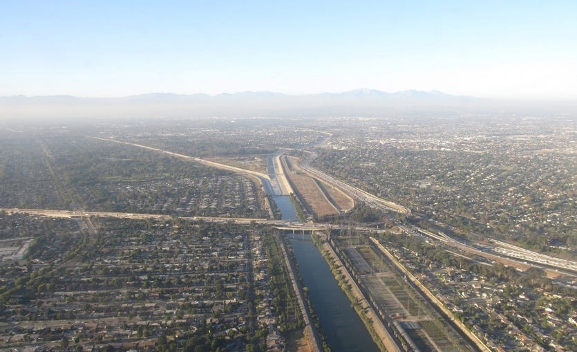
The San Gabriel river was inhabited by the Tongva natives for thousands of years along a vast flood plain. The San Gabriel River, the Santa Ana River and the Los Angeles River once drained into the Los Angeles area with frequent uncontrolled flooding. Chumash native people worked as laborers to build a dam and an aqueduct to control the flooding. I wonder how much human intervention has changed the flow of the water and the surrounding landscape. Now the San Gabriel is a channelled waterway.
The East Pacific Rise (a mid-ocean rise that extends across the Pacific Ocean) and the San Andreas Fault terminate at the south end of the Salton Sea creating an active seismic spreading center. The basin of the Salton Sea quickly fills with sediment and is 20,000 ft deep. Could these massive plates be shifting what was once the island of California northward into the mainland?
In the southern California region of the San Andreas fault line, frequent earthquake swarms happen in what is called the Brawley Seismic Zone. This is located west of Cahuilla near the city of Santa Barbara. In 1812 there was a magnitude 7.1 magnitude earthquake and Tsunami which destroyed the Mission and town. Thirteen days later another 6.9 - 7.5 M quake also struck San Juan Capistrano. At a trench near the north shore of ancient Lake Cahuilla, earlier fault events at the San Jacinto fault zone date to between 885- 1440 AD.
At Monterey Bay, there is an ancient canyon and huge sedimentary bed called the Monterey fan. This area is too massive to have been created by the modern coastal streams like the Salinas River. It was a process of turbidity erosion that carved out the Monterey Canyon which could have been an outlet for the Colorado river draining into Central Valley Los Angeles. According to geologists, this can only happen at the mouths of large rivers such as the Amazon. So, one theory suggests that at the time that the Gulf of California came into being, the horizontal slip of the tectonic plate has moved the canyon north from where Santa Barbara is located.
So far, only "recent" sedimentary cores have been obtained from this region. The oldest sediment is buried too deep. Whether these geological events happened recently or in ancient times, I think there is definitely evidence to support the possibility that California was once indeed an island!
California as an island (Rare maps)
Las sergas de Esplandián by Garci Rodriguez de Montalvo
1812 Santa Barbara Earthquake & 1812 Capistrano Earthquake
You may also like this Simmystery article:
ha ha, yes!
... and this is what came up on google: "the Pacific Plate is moving north and west relative to the plate that holds North America". Also it is moving in that direction about 3 inches per year. By the way the google search shows, the "North American Plate is moving west-southwest" "about 1 inch per year". Also, the Pacific Ocean is "shrinking", every year" -it gets about an inch smaller per year. WOW. Well there brings another theory, it isn't that the Ocean is 'rising' it is that we may be 'losing coastline' due to the 'push' of the North American Plate 'advancing' in that direction. Therefore the ocean water is 'crashing' against the Continent -as a possibility.
Well aside from all that, going back to the original comment, (and the theory that the Pacific Plate is "crashing in" to the Continent of North America), maybe this is not really a contradiction, (that the Pacific Plate is moving North and West -because to say it is 'crashing' into the continent it has to be moving 'east' technically). In fact, the theory that the Pacific Plate is 'bumping'/'crashing' into the North American Continent may actually hold up to the 'fact' of a West and North movement/direction of the Pacific Plate. To further analyze the movement, the perception and actual data that the 'direction' of the Pacific Plate is actually North and West, (and not 'crashing' 'into' the continent of North America and therefore eastward) may actually be due to the movement of the 'crashing'! In other words, the 'crashing' movement causes the Pacific Plate to be constantly/consistently resisted against by the Continent/ North American Plate and therefore the North American Plate is pushing the Pacific Plate 'away' from it, In the direction of the West and North. The North American Continent is perhaps appearing totally stable, (in fact it is moving too -west-southwest -google search) and therefor it may make some sense that it is in turn 'pushing' the Pacific Plate North and West --- simply because there is so much resistance pushing back against the 'crashing in' towards it movement. We don't 'see' the Pacific Plate moving 'east', (ie: what may explain the California island joining the continent and becoming part of it -if that is what happened as in this commented theory). Rather, this battle of the plates basically creates the situation of the Continent/North America Plate 'standing' or pushing 'against' the Pacific Plate' and, (in fact) actually causing the movement in the direction towards North and West. No matter how much 'force' is the Pacific Plate may be directing east and 'in' to the North American Plate, it 'moves' North and West as a result of the forces at play. Meaning the Continent land mass of North America is so much 'stronger' than the Pacific Plate, and that the Pacific Plate has "no where to go" but North and West. To illustrate this imagination of forces, if I push a much stronger, bigger person than me, the resulting "motion" of my body 'against' theirs ultimately 'pushes me' out and away! Their body doesn't budge, (at all) and merely 'resists', (by mere size and weight). Like running into a 'brick wall', one will just 'bounce off'. So the 'bigger larger bully' one may try to push against is simply 'standing their ground' no matter what force one brings against 'it'. In this case, the 'bully', the North American Plate, is actually even 'moving' -or one might imagine "leaning" into the Pacific Plate as it 'approaches' it, because the North American Plate is in fact moving west and Southwest 'against' the theoretically "incoming" Pacific Plate! So in addition to size, the North American Plate is in 'motion' towards/against the 'incoming' energy. The Pacific Plate is 'trying' to move 'into' the Continent of North America and simply "bumping off" of the land mass and the resulting 'bounce off' sends the Pacific Plate in the direction of North and West. Maybe.... Ok, well that is enough for one day of a totally amateur 'science' attempt.... oh my. That does make some sense if California had once appeared as an island. It moved in the direction of the Pacific Plate it is on top of, squeezing towards the Continent, (connecting the top of the Pacific Plate/California land to the North American Land, eliminating any water in between and also forming the Mountain ridges) and constantly moving into an endless 'bounce off' movement into the direction of the North West, (even as the North American Continent inches West and Southwest). When the San Andreas fault activates, it is not 'splitting'/cracking more, it is the Pacific Plate 'bouncing' against the Continent in a slow motion, groaning motion with a very strong resistant force 'against it' sending it 'back' / away to the North and the West. So anyway, a lot of words to describe this, but it was a fun attempt at a theory as to why, (even if California/Pacific Plate may be 'crashing in') the California land ultimately is moving "north" and "west", (basically due to the resistance of the North American Plate's size and movement against it). Wow, fun imaginings. I see it in my mind even if words are tedious to explain.
and there is this from the google search:
Is the Pacific Plate shrinking?
The Pacific Ocean is shrinking. Every year, it gets about an inch smaller as the tectonic plates that the Americas sit on are pushed westward. Now, thanks to calculations by a supercomputer, scientists say that a new “supercontinent” will eventually emerge due to this process: Amasia.
to this I speculate....
hmmm.... more mountains and land to the west? not breaking away but rather 'building up?!
I like the curiosities. My mind was thinking that California may have moved 'into' the east, like 'crashing' into the continent.... thus being the cause of the pushing of the land upwards and creating the mountains and such. That would be the opposite of saying California will 'split off' and 'fall into the ocean'... ha ha.... the earthquake fears/statements/theories of California "breaking away from the continent" may have it 'backwards'. Anyway, isn't there some facts that Pacific Plate 'buckling' 'under' the continental plate? I just don't remember. If the pacific plate is folding under the the continent, (if that is true) it may bolster that idea that we are not 'splitting' from the continent, but rather are 'crashing' into the continent. This idea the surface of California was an 'island' may fit into that idea very well. It only came to mind as I saw the 'California Island Map' presented here. Never would have thought of this idea otherwise. The "top" of the land -of the island of California has moved into the continent and is slowly crashing further and further inland -maybe! hmm.... I feel safer now that I don't feel California will 'break away', and instead will press into the land further and further -perhaps. Anyway, thanks for the research and maps, fun to ponder it all.